 Accommodation | International
Flights | Domestic
Flights | Tours
| Travel
Insurance | Car
Hire | Visas
| Shopping
| Dating
| Humour
Accommodation | International
Flights | Domestic
Flights | Tours
| Travel
Insurance | Car
Hire | Visas
| Shopping
| Dating
| HumourWeather, when to go?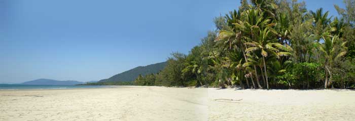
Time your holidays so you catch the good weather, in some places it can make a huge difference to your holiday as Australia is a land of extremes.
The Australian Bureau of Meteorology has a website where you can check up on weather and warnings in every place around Australia.Weatherzone.com.au can tell you the weather in just about any location in Australia simply by typing the name of the location in this search box;
Or see the city of your choice below and click the banner for a more comprehensive forecast...
 |
 |
 |
 |
 |
 |
 |
 |
 |
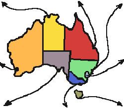
Queensland
Queensland is known as Australia’s "sunshine state"
although weather conditions vary greatly between the coastal plain
and the inland.
Brisbane averages 7.1 hours of sunshine a day in winter. Inland,
the days are warm and sunny and the nights cold and frosty, particularly
in the south. Queensland’s wet season is from December to
March, when the northwest monsoons sweep down from Asia and cyclones
are most prevalent.
Annual rainfall can exceed 4000 mm in the north, in 2002 the rainfall
was up to 7000mm. In the north-west, Mount Isa averages less than
400 mm a year and the average dwindles to about 200 mm in the south-west
corner. Brisbane averages 1200 mm.
Cape Tribulation, north Queensland: The peakseason of July and August
gets cool nights as low as 13 degrees and often strong winds. The
end of the year is a better time for water based activities like
reef trips and sea kayaking as the oceans are usually calm, rains
do not usually set in till early February. Although the rains can
be heavy and cut you off for a day or so, it is an interesting time
to visit as as the rainforest and creeks are at their wildest best
during this time.
New South Wales
Daily summer temperatures range from 14 to 23 C in the coastal areas, 11 to 20 C in the mountains and 16 to 31 C inland. In winter, temperatures range from 7 C to 14 C in coastal areas, 0 C to 5 C in the mountains and 5 C to 16 C inland. Snow settles on the Australian Alps in the north-east of Victoria from June to September.New South Wales lies in the temperate zone and the climate is generally free from extremes of heat and cold. The greatest heat is usually experienced in the north-west; a shade temperature of more than 51°C has been recorded at Bourke. The coldest region is the Snowy Mountains, where winter frosts and snow are experienced over long periods. Rainfall varies widely over the state, gradually diminishing to an annual average of 180 mm in the far north-west.Temperatures vary widely but most of the State falls within the warm, temperate belt of the south-east corner of Australia, characterised by warm and dry summers and cool to mild, wet, winters.
Victoria
Rainfall is heaviest in the eastern highlands, in Gippsland in the east of the State and in the Otway Ranges in western Victoria. Some areas receive annual rainfalls of more than 1000 mm. Lowest falls are in the Mallee region, where the average is 327 mm. Melbourne’s average rainfall is about 660 mm a year.
South Australia
South Australia enjoys hot dry summers with relatively mild nights and cool winters, with most rainfall occurring during May to August. Adelaide's average daily maximum temperature in January is 29°C, and in July 15°C. South Australia is the driest of the Australian States and Territories. Its average annual rainfall is 528 mm, but just over 80 per cent of the State receives an average of less than 250 mm of rain a year.
Western Australia
From its tropical north, to temperate areas in its south-west corner, Western Australia experiences a variety of climatic conditions.With distance from the coast, rainfall decreases and temperature variations are more pronounced.Perth averages eight hours sunshine per day and 118 clear days per year. Mean monthly maximum temperatures range from 17ºC in July to 30ºC in February. Even in the coldest months, minimum temperatures rarely fall below 5ºC. Most of its 802mm annual rainfall occurs in the winter months.
Northern Territory
Rainfall varies from an average 1570 mm a year in the far north to less than 150 mm in the south. About two-thirds of the Territory receives less than 500 mm a year. In the north, monsoonal influences produce two definite seasons known locally as "the wet" (October to April) and "the dry" (May to September). During the wet season, the coast is subject to tropical cyclones (hurricanes or typhoons).The temperature in Darwin remains almost constant throughout the year. The daily average maximum in January is 31.8 C and the average minimum 24.8 C. In July, the average maximum is 30.3 C and the minimum 19.3 C. Although most tourists come in the dry season the wet season, now also marketed as the green season, also has its attractions.
Tasmania
Tasmania has an undeserved reputation of not having very good weather. The cool, temperate climate of Australia's island state with its distinctive four seasons, (reminiscent of conditions in central Europe without the severe winters) makes this place ideal for year-round comfortable living and touring. The long summer evenings provide opportunity for extended sight-seeing with darkness coming slowly. Although the island is small compared to the mainland it still has variations in weather; the Tasmanian East Coast is milder, the West Coast wetter and the NW Coast windier.
The occasional deep low in the Southern Ocean, usually in springtime, can produce a gale that "blows dogs off chains" (the island is located right in the Roaring Forties after all). During summer, autumn and winter successive days of calm, balmy weather compensate, while no-one has ever complained about the regular afternoon coastal seabreeezes from October through to May.
More weather links ;
Anything we missed? Contact us!
HOME PAGE
Tourist Information
General Information
And Entertainment
ACCOMMODATION IN AUSTRALIA
Bed
& Breakfast
Budget
Accommodation
Backpackers Hostels
Hotels
in Australia
CAR HIRE IN AUSTRALIA
Australia Rental Cars
And
Campervans


TOURS
IN AUSTRALIA
What To Do In Australia
On-line
Shopping
On-line
Dating
![]()
About
Australia
Visas For Australia
How
To Get To Australia
How To Get Around
Travel Insurance
Travel Guides
Working
In Australia
Australian
Posters
Survival
Tips
Weather,
When To Go

Use of
this website constitutes acceptance of the User Agreement for this website
Contact us |
Advertise on this site
| Link to this site |Add
your photos or stories to this site |
Webmasters | Affiliates